Experienced
Qualified
Insured
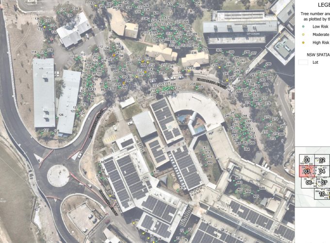
At ArbCert, we integrate advanced GIS (Geographic Information Systems) and spatial analysis into our arboricultural consulting. Accurate mapping is essential for understanding tree locations, root protection zones, canopy cover, and their relationship to proposed developments.
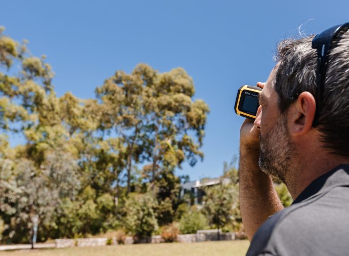
Our AQF Level 5 and 8 arborists use GIS technology to capture and analyse spatial data, helping you make informed decisions from the earliest planning stages through to compliance reporting. Whether you are a council, developer, or land manager, we deliver clear and precise mapping that supports your project outcomes.

Spatial analysis in Geographic Information Systems (GIS) involves examining and interpreting location-based data to identify patterns, relationships, and trends within a site or landscape. While GIS provides powerful tools for mapping and visualising features such as individual trees, tree populations, and root protection zones, spatial analysis goes further by enabling data-driven problem solving.
In arboriculture, GIS and spatial analysis are used to evaluate canopy coverage, assess risk zones, model Tree Protection Zones (TPZ) and Structural Root Zones (SRZ), and integrate tree data with development site plans. This process helps identify potential conflicts early, supports compliance with AS 4970-2025, and informs better planning, design, and management outcomes.
By combining precise mapping with arboricultural expertise, spatial analysis ensures that decisions about tree retention, risk, and development impacts are based on accurate, site-specific data.
GIS and spatial analysis provide powerful, real-time insights into the trees on your site, helping streamline tree management and development planning without the need for constant site inspections.
Accurate mapping allows you to instantly visualise tree locations, populations, and protection zones across your site. This data can be accessed on multiple devices, making it easy to coordinate with architects, planners, and contractors.
Problem areas, such as hazardous or high-risk trees, can be quickly highlighted using overlays, filters, or tagging. This enables targeted intervention and ensures that high-value or high-risk trees are managed appropriately.
GIS creates a living database of tree data that can be updated, aggregated, and reused for future projects. This continuity of information supports better long-term planning, compliance, and informed decision-making.
Applied GIS and spatial analysis bring together advanced tools for data collection, mapping, analysis, and reporting. These tools significantly improve efficiency in tree inventory, inspections, and urban forest management by turning raw data into actionable insights.
Through GIS software, arborists and planners can:
Applied GIS provides an evidence-based foundation for arboricultural planning and compliance, ensuring decisions are informed, accurate, and effective.
Our GIS work is guided by qualified arborists, ensuring that mapping outputs align with practical arboricultural knowledge and compliance standards.
We deliver data that is accurate, visually clear, and easily integrated into development and council reporting processes.
From single-site development to council-wide tree audits, ArbCert adapts our GIS services to your project scope.
ArbCert meets all relevant Australian Standards and Work Health and Safety requirements. We are fully insured, including public and product liability cover up to $20 million, giving you confidence and peace of mind on every project.
At ArbCert, we combine expert arborist knowledge with cutting-edge GIS technology to deliver smart, data-driven tree management solutions. Servicing Maitland, the Hunter Valley, Lake Macquarie, Port Stephens, and Newcastle, we provide tailored mapping, analysis, and reporting to support informed planning and sustainable outcomes.Contact us today to discuss how our GIS and spatial analysis services can be customised to meet the unique needs of your site or project.
Contact UsSpatial analysis in GIS can allow for the data extraction; aggregation of new and old data; overlay analysis; computation of statistical calculations and modelling; and much more.
Spatial Analysis in GIS can help tree management as it allows arborists to map, tag and visualise tree populations as well as analyse them for planning or problem solving purposes. This can increase the efficiency of tree surveys, ongoing maintenance schedules, inspections, tree risk management and reporting.
Our team includes AQF Level 5 and AQF Level 8 consulting arborists with extensive industry experience. We bring a high level of technical knowledge to every assessment, ensuring our advice is credible, defensible, and aligned with best practice.
We deliver clear, accurate reports that meet council planning requirements and Australian Standards. From early-stage assessments to detailed impact reports, our work supports confident, informed decision-making.
As a small team, we value strong working relationships and direct communication. You’ll work with experienced arborists who understand your project and are committed to providing reliable, practical guidance every step of the way.