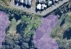
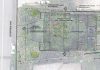
Accurate tree mapping is an important part of professional arboricultural assessment. A precise tree location helps an arborist understand its relationship with buildings, infrastructure and proposed development.
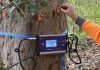
At ArbCert, we use professional GNSS tree mapping technology during our site assessments. Under suitable conditions, our equipment can achieve positional accuracy down to approximately 30 cm.
We integrate this spatial information directly into our digital mapping and reporting workflow.
Accurate tree locations are particularly valuable for Arboricultural Impact Assessments (AIAs) and Tree Risk Assessments. Better location data helps us assess impacts more accurately and prepare clearer reports. It also supports better-informed decisions about tree retention, protection and management.
GNSS stands for Global Navigation Satellite System. The technology uses satellite positioning to determine a location on the ground.
Professional GNSS equipment provides greater spatial accuracy than estimating tree positions from aerial imagery or manually marking approximate locations on a plan.
ArbCert combines GNSS equipment with our digital field assessment and Geographic Information System (GIS) workflow.
During an inspection, we can record each tree’s location and link it with assessment information. This can include:
Under suitable site and satellite conditions, our GNSS equipment can achieve accuracy down to approximately 30 cm.
The result is more than a point on a map. It creates a spatial record that connects each tree with its assessment data.
The location of a tree provides important context for an arboricultural assessment.
On sites with many trees, accurate mapping helps us identify individual trees during future inspections or construction works. It also helps contractors and property managers locate trees that require specific management.
Accurate tree mapping reduces reliance on descriptions such as “large eucalypt near the northern boundary”. It also provides a better alternative to manually estimating tree positions.
Good spatial data becomes even more valuable when we compare trees with other site features.
These features may include:
More accurate locations give the arborist better information on which to base recommendations.
Accurate tree location data can significantly improve an Arboricultural Impact Assessment.
An AIA examines how proposed development may affect existing trees. It also identifies measures to retain and protect suitable trees during construction.
To do this well, the arborist needs to know more than the species, size and condition of each tree. They also need to understand exactly where each tree sits in relation to the proposed works.
ArbCert can compare GNSS tree locations with available survey and design information.
This helps us assess potential conflicts with:
This becomes especially important when development occurs close to a retained tree.
Tree location directly affects the spatial relationship between a tree and proposed development.
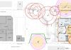
For example, the calculated root protection area extends outwards from the tree. A difference in tree location can therefore change the measured extent of an encroachment.
Better spatial information gives the arborist greater confidence when assessing these relationships.
It can help determine whether works create a minor interaction or a more significant conflict. It can also identify where design changes or construction controls may improve tree retention.
In practical terms, better tree mapping supports better development decisions.
Project teams often provide a feature or detail survey for an Arboricultural Impact Assessment.
However, surveys do not always show every tree relevant to the proposed works.
A survey may omit trees for several reasons. Vegetation may have changed since the survey. Trees close to the property boundary may also fall outside the original survey scope.
Neighbouring trees can still affect a development where their crowns or root protection areas extend into the site.
GNSS tree mapping allows ArbCert to record these additional trees during the arboricultural inspection. We can then include their locations in our assessment and mapping.
This provides a more complete picture of the vegetation that may influence the project.
No. GNSS tree mapping and registered land surveying serve different purposes.
A registered surveyor should provide certified property boundaries, levels and other cadastral information where the project requires it.
ArbCert uses GNSS to accurately capture the locations of trees relevant to our arboricultural assessment.
The two types of information can work together.
Survey and design data provide the development context. GNSS tree mapping improves our understanding of where the assessed trees sit within that context.
Accurate mapping also provides major benefits for Tree Risk Assessments.
This is particularly useful on sites with large tree populations. Examples include schools, parks, commercial properties, residential communities and campgrounds.
GNSS mapping gives each assessed tree a defined spatial location.
We can link that location with information such as:
This creates a clearer tree-management record for the property owner or asset manager.
Accurate locations can also help contractors find the correct trees when carrying out recommended works.
For ongoing management programs, the spatial record helps arborists return to individual trees during future inspections.
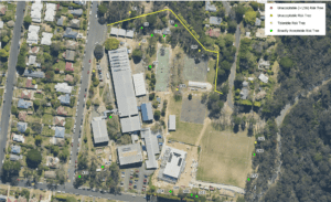
Under suitable conditions, ArbCert’s professional GNSS equipment can achieve positional accuracy down to approximately 30 cm.
Actual accuracy varies with site conditions.
Factors that can affect GNSS performance include:
Our field workflow allows us to consider the quality of the captured location data when using it within an assessment.
Where the exact relationship between a tree and a surveyed feature is critical, additional survey information may still be necessary.
The value of GNSS extends beyond the accuracy of an individual coordinate.
ArbCert integrates tree locations into our broader GIS and digital field assessment workflow.
We can connect each mapped tree with the information collected during the site inspection. We can then use the same spatial data when preparing plans and arboricultural reports.
Depending on the project, this may assist with:
This integrated approach reduces the need to manually transfer tree locations between field notes, plans and reports.
It also helps maintain consistency between the tree we inspect on site, its location on the plan and the recommendations in the report.
That becomes particularly valuable on projects involving dozens or hundreds of trees.
Technology does not replace the experience or professional judgement of a qualified consulting arborist.
It does, however, provide better information on which to base that judgement.
Accurate tree mapping helps ArbCert prepare clearer and more spatially reliable arboricultural assessments.
For Tree Risk Assessments, GNSS mapping helps identify individual trees and supports ongoing management.
For Arboricultural Impact Assessments, accurate locations help us assess proposed development against existing trees with greater confidence. This can improve impact assessment, identify conflicts and support appropriate tree protection measures.
By combining professional arboricultural assessment with GNSS tree mapping, ArbCert can provide better spatial information for tree management and development decisions.